
![[Writing Task 1 - Map] The map below shows the Road System as it is now and proposed changes in future to reduce the number of accident.](https://www.hrsviet.com/uploads/0000/1/2026/01/31/mapenglandbanner.jpg)
Band 6.5 |
Band 7.0-7.5 |
||||||||||||||||||||||||||||
|
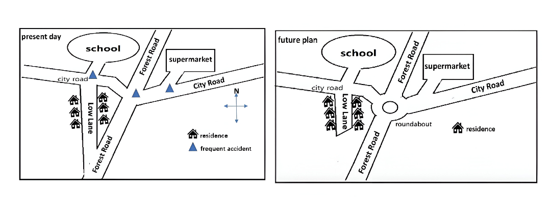
The two maps illustrate what construction will be carried out in an England residential area for the purpose of reducing the possibility of traffic accidents. As shown in the first map, the frequent accidents usually take place in three spots: the first one is on the west of the City Road, just in front of the school. The second one is at the spot where Forrest Road intersects with the City Road. And the third one is at a small pathway, in conjunction with the east side of City Road. At present, from the north to the south is the main road Forrest Road, it is in conjunction with the City Road which extends from the west to the east. The west side of the City Road leads to the school, and it is located in the north-west of the residential area. The Low Lane directs to the living district, which sits in the west to the Forrest Road. The lane is in conjunction with both the City Road and the Forrest road. The supermarket is situated to the east of the Forrest Road, residents can get groceries there by driving along the City Road. In the future, it is noticeable that a roundabout will be built in the centre of the Forrest Road, which might reduce the speed of the vehicles. Another noticeable change is that the south side of the Low Lane will no longer be connected to the Forrest Road. For those residents living in this district wishing to go to the main road, the only way will be driving back to the City Road and passing the roundabout. Overall, this proposed road system is likely to be more fully developed in order to avoid traffic accidents |
The two maps illustrate the proposed changes to a residential road system in England aimed at reducing traffic accidents. Overall, the main developments include the construction of a roundabout at the junction of Forrest Road and City Road, as well as the closure of part of Low Lane to limit direct access to the main road. At present, Forrest Road runs from north to south and intersects with City Road, which extends from west to east. To the west of City Road is a school located in the north-western part of the area. Low Lane connects both Forrest Road and City Road and leads to a residential neighbourhood. In addition, a supermarket is situated to the east of Forrest Road and can be accessed via City Road. In the future, a roundabout will be built at the intersection of Forrest Road and City Road in order to control traffic flow. Another significant change is that Low Lane will no longer be directly connected to Forrest Road. As a result, residents will have to use City Road and pass through the roundabout to reach the main road. |
||||||||||||||||||||||||||||
|
❌ Lỗi
Lỗi nhẹ nhưng nhiều: |
✔ Những điểm đạt Đúng format giám khảo Từ vựng học thuật chuẩn
Map Task 1 không bao giờ: |